27 May 2025

Trip to Kongo Central and DRC's coast


In December 2024, we took our long-delayed trip to Kongo Central province and specifically Muanda, on DRC's coast. We'd previously planned to travel there in December 2022, but heavy rains washed away a portion of the N1/Route de Matadi (the main highway leading from Kinshasa to DRC's port in Matadi). Some repairs were made, but large sections of the road were one-way which would have made an already slow drive even longer.


View of Matadi and the Congo River.


The longest portion of the drive is between Kinshasa and Matadi, due to the trucks going back and forth from the port. Aside from traffic getting in and out of both cities, the trip went smoothly. For all legs of this trip we got rides in smaller cars/taxis. The Kin-Matadi ones were arranged by calling in advance (you reach a call center then they pass on your number and the driver calls you to coordinate, usually after 10 PM the night before travelling), while for the other drives we just told people at our lodging that we were looking for a ride to Boma/Muanda/Matadi and they found us a taxi. So it was pretty easy to get around.

Hôtel Metropole, Matadi.


Kinshasa to Matadi took about 8 hours, which wasn't too bad considering that the last time we were on this road it took a convoy of us 9.5 hours to get from Kisantu to Kinshasa (120 kms), and I was one of the drivers.


After a night in Matadi we continued to Boma, the capital under King Leopold II's Congo Free State until 1923. We later learned from some other customers at the bar/historical sight Belvédère that it was not the first capital of the Congo Free State, and that Vivi across the river from Matadi held that status from July 1885-May 1886. 


Ship heading past Boma up the Congo River to Matadi.


Boma is a quiet town with a number of historical sites worth visiting. These mostly stem from DRC's colonial history - churches, government offices, etc. - but Boma is also host to what are reputedly the first cars in the Congo. These are understandably in a state of disrepair, not least because our kids (among other visitors over the years) were allowed to "drive" them.

The first cars in the Congo, they belonged to a German named Fischer.


We then headed north to INERA Luki, and agriculture and forestry research station where a TASOK colleague of ours grew up. His brother continues to work there, and was a great help getting to and from Luki (i.e. finding a driver who was willing to take us the 6.5 kms offroad to reach INERA, then riding with us) and then when we had a family member fall sick and need medical treatment in Boma.


Dimensions of Central Africa's biggest tree.


The illness unfortunately cut our INERA Luki visit down to one night instead of three, but most of us were able to do a small hike with Papa Bambi to see what is reputedly the largest tree in Central Africa. Our host described 30-40 other sites of interest, so we hope to return to Luki again.


Onwards to Muanda, which was just a 1-1.5 hour drive from Boma. Once you get past the port at Matadi and cross the river, traffic is much calmer thanks to the smaller amount of heavy goods trucks on the road. Besides increased traffic, the Matadi-Kinshasa also features numerous truck breakdowns (or trucks that veered into the deep gutter alongside the highway), which requires drivers to weave around them while on the lookout for oncoming traffic.

Fishermen at Tonde beach, Muanda.

In Muanda we stayed at a guesthouse on the grounds of a Catholic church, Maison d'accueil des Sœurs de la Charité. This was a couple of hundred meters from Plage Tonde, a pleasant enough beach with chairs and umbrellas available for the cost of a drink, with shrimp, fish and other food available on the grill. The sea was a bit rough, but the kids enjoyed riding the waves near shore, building in the sand, and, one time, helping fishermen pull in their net (they offered us a decent-sized fish for our efforts, despite a meager haul for what was a lot of effort on their part).


A couple of hundred meters from the main public beach is a section abutting Hotel La Beviour, and across a small lagoon is a turtle hatchery managed by ICCN - Institut Congolais pour la Conservation de la Nature (the Congolese wildlife authority). When sea turtles lay their eggs, ICCN staff collect them and bury them in a designated area for safe-keeping and protection. Once the turtles hatch they are then released onto the beach to head out to sea.


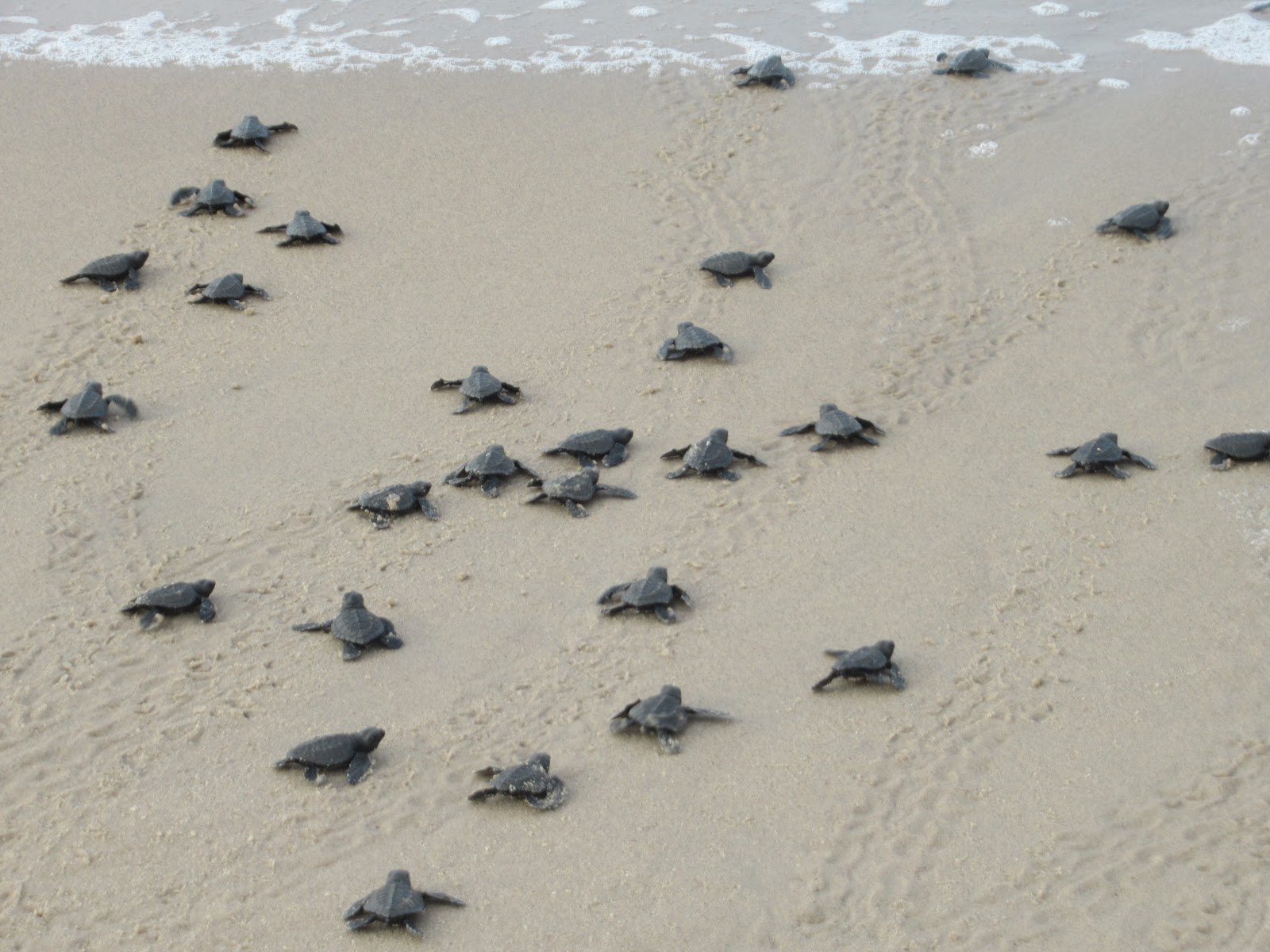
Per Christian at the ICCN outpost/hatchery, the turtles, Olive Ridleys, laid eggs in October and about five weeks later they hatch. So every day there were 1-2 batches of turtles hatching, so we went twice to help count them and release them onto the beach.


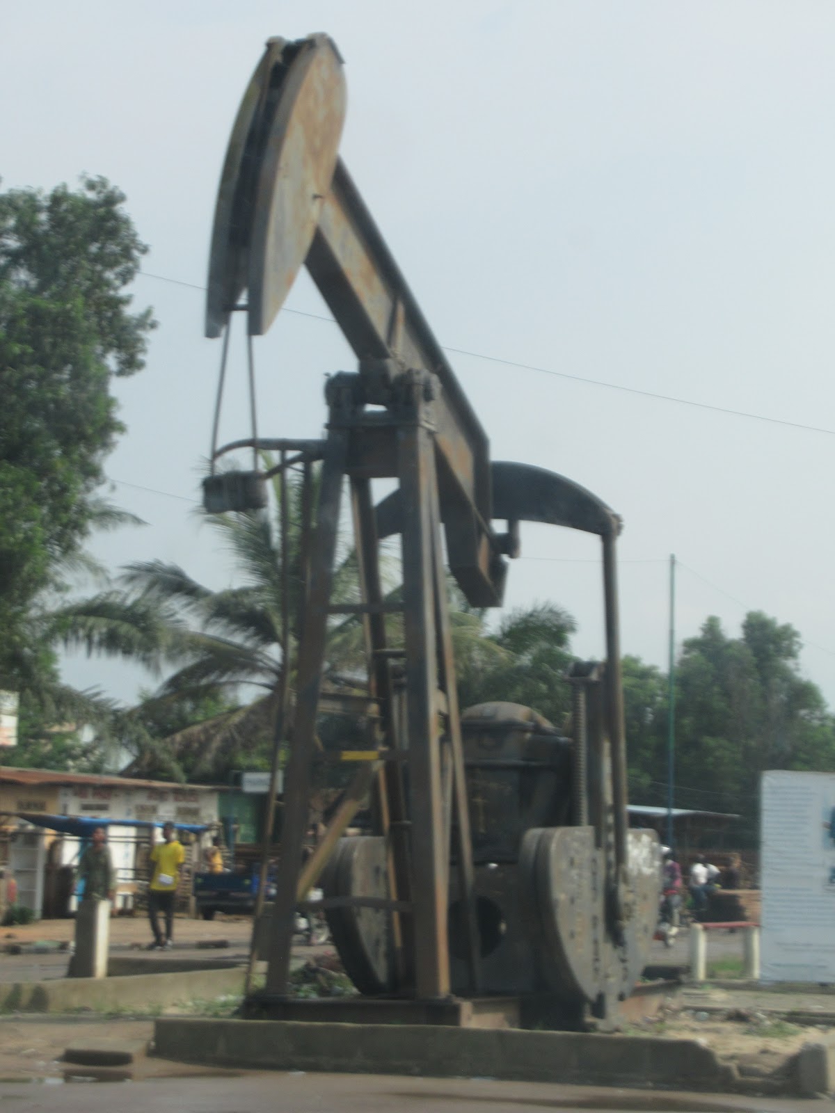
(Left: first church in Congo, brought prefabricated from Belgium. Right: oil derrick monument, Muanda.)

Since Kongo Central was part of the former Kongo kingdom, I was a bit surprised to hear Lingala so widely spoken as opposed to KiKongo (not that I would have recognized the latter). One of our colleagues had previously explained that Mobutu was responsible for the spread of Lingala throughout DR Congo. Mobutu was from an area where Lingala was the principal Congolese language. As he built up the Congolese/Zairois army, Mobutu initially mainly recruited soldiers from his home region. Their deployments around the country helped spread Lingala, as did the adoption of Lingala by people who joined the predominately Lingala-speaking military.

Former Governor's residence, Boma.

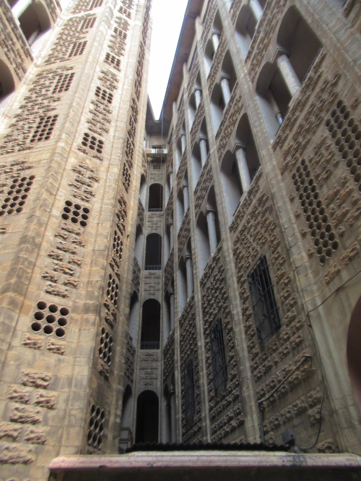
On our return trip through Matadi, we made a visit to Belvédère, sight of a hillside monument to the construction of the train from Matadi to Kinshasa (built to bypass the rapids on the Congo River). The main feature, a bronze topographical map mounted on marble, is mostly surrounded by a bar/restaurant, although it was covered in a tarp to protect it from the rain.


The bronze map matches the view from Belvédère, and a gentleman quickly arrived to point out various key locations (a monument to porters who died during the railroad construction, the first electricity substation) and history. The map was made in Belgium and brought to Congo in 1948.

"Across this chaotic land, bold and tenacious men
 launched the first railway in Central Africa."


Overall, it was a very enjoyable trip. We hope to go again sometime, to spend some more time at Luki, and also to head to Pointe de Banana, where the Congo River empties into the Atlantic Ocean.

18 April 2020

Porto-Novo, Benin (Dec. 2016/Jan. 2017)

Bootlegged petrol from Nigeria for sale on the Abomey-Cotonou road.
Before a final couple of days in Cotonou, we headed to Porto-Novo, Benin's sleepy capital across the lagoon.

Photographing artifacts wasn't allowed either.
We visited the Musée da Silva, in a compound/large family house owned by an Afro-Brazilian named Urbain Karim da Silva. Many Afro-Brazilians converted to Islam, while others were Christians. One name among the photographs - Khabir Noel da Silva.

Mural at Musée da Silva depicting various Vodoun deities.


There were girls' and boys' sides to the house, next to the mother's and father's bedrooms, respectively. There was a room with photographs of eminent African and other world leaders. This room also featured a large panel of Jimmie Rodgers memorabilia - Urbain Karim was a big fan of him.
Eglise Notre Dame, built in the 1880s, and some prominent clergy members' busts.


One interesting display was on Abram Petrovich Gannibal, great-grandfather of Alexander Pushkin. While his origins are somewhat in dispute, the emerging consensus is that Gannibal was abducted from northern Cameroon, enslaved and taken to Russia. He eventually was raised as member of the imperial court and served as a general in the Russian military. So, an illuminating find in an Afro-Brazilian museum in Benin.

Toffa I, the last sovereign king of Porto Novo. He established the first connections with the French before colonialism.

While most of the furniture was showing its age, there was also early 20th century printing equipment that seemed in better shape - printing presses, type setting machines, and a stapler.

The Afro-Brazilian built Great Mosque, with its modern successor.


Another stop in Porto-Novo was the Royal Palace. We had a brief audience with the current king, King Toffa IX, whose role is largely ceremonial these days.

Toffa I ruled from 1874-1908. The current king was enthroned in 2007.
We also discovered a great bookstore owned by Joelle Esso, Cameroonian author of Eto'o Fils, an autobiography co-written with (as told by) Samuel Eto'o. Mme. Esso is also a singer and comedian, and it was a pleasure to meet her in this little bookstore, where we were also able to pick up a copy of "Abraham Petrovich, Le Prince Noir de Russie," a nice bookend to our visit to the Musée da Silva.

s

Our lodging in Porto-Novo was at the Songhai Center, a sprawling production and training center with a wide range of activities - farming, livestock rearing, a boutique and restaurants. We rang in the new year fairly quietly with palm wine and baked goods produced locally.


05 March 2020

Abomey, Benin (December 2016)


On our return south we spent a couple of days in Abomey, capital of the Dahomey empire. The city was really spread out, on account of the various kings' palaces as well as training palaces built around town.

Market for princesses and wives of kings. The citizenry weren't permitted to see them, so King Agadja (1711-1742) created this market so they could still shop for needed items. The market also housed a divinity that protected the site from unfortunate events.
We took a tour with Bonaventure, visiting several of the kings' palaces. We also checked out a few "palais privés" - training palaces or finishing schools for princes. The palais privés are empty as no one can agree on who should live in them.

"Let's unite for the viability of our palace."
A colonial site that we visited was the "Cercle" - the campement (camp/base) of the French. The building was built in 1928 as the French didn't eat local fare and "needed a hygienic base" for their food and their bodies. Access by Beninois to the camp was banned until independence in 1960, as the French also feared they would poison them. The cercle was one of the colonial subdivisions and French administrators were based in another building on these grounds.

Le Cercle / Le campement des Français.

We also passed by Cathédrale Saints Pierre et Paul, built by the Portuguese in 1721 with the approval of King Agadja. The Portuguese were instrumental in the early trans-Atlantic slave trade, and found in the Dahomey empire willing intermediaries. The first church built for the kingdom was constructed in the private palace of king Guezo (1818-1858), who was later baptized Joseph and married a Portuguese woman following his conversion.


Agbodo: Pit of fortification of the city. The pit and walls extended for 10 km around the core of the kingdom. The pit was apparently filled with poisonous plants and wild animals.
Bonaventure and Blair outside one of the many palaces of Abomey - this one for king Houegbadja.


King Houegbadja (1645-1685) was the founder of the Dahomey kingdom. He expanded the kingdom without waging war, instead forming political agreements with people indigenous to the areas he ended up controlling. Houegbadja's symbols were the fish, the net, and the hoe. He wanted these symbols to show that he wouldn't be trapped, he was cunning, and he was ready to defend himself.

These informative signs are all over Abomey (and Benin in general)!
The queen Hangbe, daughter of Houegbadja and twin of king Akaba, took power after Akaba's death. She created the famed Amazon corps, but abdicated under pressure from royals who wouldn't accept a female on the throne. Her brother and predecessor created a new saber for decapitating his enemies, and encouraged diverse forms of crafts including cutting of precious stones, embroidery, pottery, and dyeing of fabric!

King Gbehanzin was the last king of Dahomey (1890-1894). He's depicted here turning away the foreign invaders. He went to see the French to pursue a truce, but was exiled to Martinique, then to Algeria, where he died in 1906.


The next day we met up with Bonaventure, who suggested we check out an interesting site outside of town. This is how we ended up exploring a hole in the ground in Abomey's outskirts, accompanied by the members of a family compound - two students, their uncle, his wife and their daughter and baby.


Descending into the hole.


The purpose of the holes was the subject of speculation - hiding from enemies being the preferred theory. Our hosts mentioned that some holes contained ironwork from 3,000 years ago.

We had an interesting time in sprawling Abomey (including finding a mini-golf course). One curious aspect was how matter-of-fact Bonaventure and other residents were about the brutal reputation of the Dahomey kingdom. But it was greatly affected by the slave trade, which probably motivated the various expansionary wars described in the historical signs around town, and explains the lengths neighboring communities went to in order to avoid slavers.

05 February 2020

Dassa-Zoumé - December 2016

The story of the wooden horse. "Robust men spent a lot of energy pulling the horse and Otetan Adjikin Zomahoun around town."
The wizened gentleman who unlocked the room: "You can touch it if you're not afraid."

In Dassa we started off by going in search of the palace. On the way we checked out the famous wooden horse, given to a onetime king of the city. Otetan Adjikin Zomahoun was enthroned as the 23rd king of Dassa after its conquest by the Dahomey kingdom. He subsequently was a canton chief/administrator under the French, and to give himself a noble air he went about on horseback. After his first four horses died, a Portuguese friend made him a wooden horse on wheels.

Painting of the 4th king of Dassa at the royal palace.
Mortars carved into the hillside? It's been so long that I've forgotten the answer.

We then walked through the market, where a young girl from a fabric shop walked us over to the royal palace. From there a resident named Fabrice took us up to the sacred hilltop of Pace Yaka and a shrine to Ogoun, the Vodoun god of iron and war. The hills around the town were where locals took refuge from slave raids by the Dahomey kingdom.

View from hill of the Omandjagoun. It's a bit hazy on account of the Harmattan.

Tortoise rock!
The next day we went to visit Notre Dame de Arigbo church, with a lively pastel interior. The Virgin Mary appeared at a cave behind the church, and it is now the largest pilgrimage site in West Africa (Catholic division, that is).
Notre Dame de Arigbo church, Dassa.


We had a laugh with some Beninois visitors when we were met with the sign "Marchez a genoux" ("Walk on your knees). One said, "You'll be doing a little penance." To which another remarked, "It'd be more than a little penance." Ah, gentle west African humour.

Later on we took a moto to the outskirts of town then continued on foot to Maktub Farm, where Armand showed us around his rabbit-rearing project. He started in 1999 with sheep then transitioned in 2005 when the mairie/city sold the surrounding land. After 10 years or so, the rabbits developed tooth and paw problems and weren't reproducing as much. They tried disinfecting the surroundings and treating the rabbits, but decided to start a new batch this year (i.e. 2016).

Maktub Farm rabbits and a second pastel church interior.


Another challenge for Maktub Farm has been the water supply. Sometimes they'd only have water once or twice a week, and they've even gone a month without water, forcing them to buy bidongs (20L jerrycans) to supply the rabbits.

Gate at the second church.

Also in Dassa is the Okuta Site run by local artists. In 2008 the Okuta Association hosted artists from West Africa and Europe who carved masks into boulders at the base of one of Dassa's many hills.